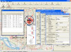
Command, Control, Communications, Computer & intelligence (C4l) is a concept whereby all the defence entities of a country share, jointly process, and fuse data to establish real time Common Operational Picture (COP). The COP consists of Recognized Air Picture (RAP), Recognized Maritime Picture (RMP), and Recognized Ground Picture (RGP). COP, along with associated operational data, provides the supreme commander with a clear status of country’s war fighting potential for the ease of decision-making during fog of war. C4l system forms a self-healing self-forming intelligent network that permits upward, downward, and lateral flow of information to bring all tiers of command at the same level of situational awareness. GIDS Integrated Command & Control System includes all the critical components for ground, air, and naval forces, including:
- Common Operational Picture (2D and 3D)
- Detection
- Tracking
- Identification
- Asset Management & Tracking System
- Intelligence Management System
- Meteorological Management System
- Mission Planning System
- Threat Evaluation & Weapons Assignment System (T EWA)
- War-gaming, Simulation, and Training System
- Voice Switching System
- Role Based Access Control System
- Digital Audio & Video Recording System
- Data Security & Encryption System
- Interfering the presence of valid targets form a series of plots and tracks recevied from different radars.
- Calculating true trajectories of the target in presense of uncertainties imposed by the sensor as well as aircraft dynamics.
- Recognizing and rejecting false targets.
- Successfully tracking and predicting the optimal estimates of the target in the presence of clutter and false alarms.
- Display target tracking information.
- Forming correct association between tracks and observation from radars in different environments.
- Successfully tracking the target during extreme condition of fast maneuver, formations, miss detection, cross-over etc.

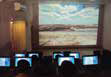
The ACMI system is designed to be range-less and can be operated without any restriction in any area. The system records the "Time Space Position Information" (TSPI) of all the aircrafts involved in the training exercises along with their essential parameters onto removable data storage.
- An effective training tool for combat pilots.
- Capture of weapon deployment events.
- Exchange of data between the participating aircraft using realtime data link.
- Notification to pilots of weapon event result such as hit and miss for missiles for real time kill removal functionality.
- Real time warning to the pilots such as collision kill/miss etc.
- Recording of time syncronized relevant information for post mission debriefing replay like .
- Chaff & Flare Dispenser, RWR, EW etc.
- Post Launch Missile fly out and bombing accuracy calculations.
- The system is installed on Mirage / F-7P / F-16 aircraft.
ARTILLERY FIRE CONTROL SYSTEM
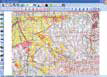
PAKFIRE is a modular, reliable, secure, user friendly and fully integrated Artillery Fire Control System that automates all operational functions of artillery and ensures fast and accurate fire on targets. It provides an automated solution for Preparation , Coordination, Dissemination, Execution and Modification of Fire Support Plan, Fire Plan and Gun Programs. It has a scalable system architecture that is suitable for present combat scenarios and can be deployed at all combat echelons. PAKFIRE interfaces with all types of external systems, like radars, meteorological systems, UAVs and Command and Control through wired/wireless media.
Major Modules
Artillery Fire Direction Module receives target information from
Forward Observers, Counter Bombardment and Fire Support
Organizations. The data of met system and non standard conditions is
then added to calculate fast and accurate firing data which is then
transmitted to guns and digital message units using wired or wireless
media.
Fire Support Planning Module s designed to integrate fire support with
the maneuver plan. It assists in the preparation, coordination,
dissemination, execution and modification of Fire Support Plan (FSP).
All types of GIS functionalities like map navigation, drawing of tactical
and military symbols, preparation of operational overlays etc have been
incorporated.
Counter Bombardment Module ntegrates external sensors like
Radars, UAVs etc with PAKFIRE for speedy transfer of information. It
assists commanders and staff in employment of Locating Resources by
providing Software Aids/Tools. It shows various charts , plots, HB List
and CB Task Table generated automatically by the system.
Supporting Functions Module enables commanders in allocation,
modification and management of resources like ammunition,weapons,
vehicles and manpower.
ARTILLERY FORWARD OBSERVOR SIMULATOR

Artillery Forward Observer Simulator (AFOS) is a computer based system whose purpose is to provide training for the forward observer of the artillery.
The system provides realistic environment for the training of observer
in a class room/simulation lab. Budget reductions and limitations of
live fire opportunities have adversely affected the proficiency of the
forward observer. For these types of reasons, an alternative method
for training the forward observer must be found to provide almost
realistic environments in order to accomplish the fire missions. One
solution is to develop and use a computer simulation system in order
to enhance training and operations.
Training of Forward Artillery Observer is a necessary and continuous process and its aim is to enhance observer's skills and capabilities. It is necessary to have a system which provides training that would enhance the capabilities of the observer to react promptly to various situations in war.
Small range practices are not enough to improve the quality of observers because the observations recorded and _ various F corrections passed are not realistic. It is essential to have a system (Artillery Forward Observer Simulator), which would enhance the quality of training of forward observers without engaging ammunition and other expenditure.


| Products | Broad Specifications |
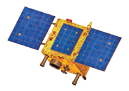
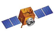
| Satellite Imagery | Resolution: 0.5 m Pan, 2m XS Resolution: 0.98 m Pan, 2.89m XS Resolution: 1.5 m Pan, 6m XS Resolution: 2.5/5 m Pan, 10m XS (Archived Imagery) Resolution: 10 m Pan, 20m XS (Archived Imagery) |
| Specialized Products | Digital Elevation Model (DEM) Digital Terrain Model (DTM) Digital Surface Model (DSM) Resolution (1m, 4m, 8m, 30m) |